Country
| France |
|---|---|
Region
| Île-de-France |
Department
| Paris |
Subdivisions
| 20 arrondissements |
Government
| |
• Mayor (2008–14)
| Bertrand Delanoë (PS) |
Area
| |
• Urban (2010)
| 2,844.8 km2 (1,098.4 sq mi) |
• Metro (2010)
| 17,174.4 km2(6,631.1 sq mi) |
• Land1
| 105.4 km2 (40.7 sq mi) |
Population (2010)
| |
• Rank
| 1st in France |
• Urban (Jan. 2009)
| 10,413,386 |
• Metro (Jan. 2009)
| 12,161,542 |
• Population2
| 2,243,833 |
• Population2density
| 21,000/km2 (55,000/sq mi) |
Time zone
| CET (UTC +1) |
Paris is the capital and most populous city of France. It is situated on the Seine River, in the north of the country, at the heart of the Île-de-France region. Within its administrative limits (the 20 arrondissements), the city had 2,234,105 inhabitants in 2009 while its metropolitan area is one of the largest population centres in Europe with more than 12 million inhabitants.

An important settlement for more than two millennia, by the late 12th century Paris had become a walled cathedral city that was one of Europe's foremost centres of learning and the arts and the largest city in the Western world until the turn of the 18th century. Paris was the focal point for many important political events throughout its history, including the French Revolution. Today it is one of the world's leading business and cultural centres, and its influence in politics, education, entertainment, media, science, fashion and the arts all contribute to its status as one of the world's major cities. The city has one of the largest GDPs in the world, €607 billion (US$845 billion) as of 2011, and as a result of its high concentration of national and international political, cultural and scientific institutions is one of the world's leading tourist destinations. The Paris Region hosts the world headquarters of 30 of the Fortune Global 500 companies in several business districts, notably La Défense, the largest dedicated business district in Europe.
Centuries of cultural and political development have brought Paris a variety of museums, theatres, monuments and architectural styles. Many of its masterpieces such as the Louvre and the Arc de Triomphe are iconic buildings, especially its internationally recognized symbol, theEiffel Tower. Long regarded as an international centre for the arts, works by history's most famous painters can be found in the Louvre, theMusée d'Orsay and its many other museums and galleries. Paris is a global hub of fashion and has been referred to as the "international capital of style", noted for its haute couture tailoring, its high-end boutiques, and the twice-yearly Paris Fashion Week. It is world renowned for its haute cuisine, attracting many of the world's leading chefs. Many of France's most prestigious universities and Grandes Écoles are in Paris or its suburbs, and France's major newspapers Le Monde, Le Figaro, Libération are based in the city, and Le Parisien in Saint-Ouennear Paris.

Paris is home to the association football club Paris Saint-Germain FC and the rugby union club Stade Français. The 80,000-seat Stade de France, built for the 1998 FIFA World Cup, is located in Saint-Denis. Paris hosts the annual French Open Grand Slam tennis tournament on the red clay of Roland Garros. Paris played host to the 1900 and 1924 Summer Olympics, the 1938 and 1998 FIFA World Cup, and the 2007 Rugby World Cup. The city is a major rail, highway, and air-transport hub, served by the two international airports Paris-Charles de Gaulle andParis-Orly. Opened in 1900, the city's subway system, the Paris Métro, serves 5.23 million passengers daily. Paris is the hub of the national road network, and is surrounded by three orbital roads: the Périphérique, the A86 motorway, and the Francilienne motorway in the outer suburbs.
Map and video:
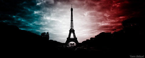
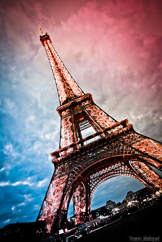
Eiffel Tower
| Construction started | 1887 |
|---|---|
| Completed | 1889 |
| Opening | 31 March 1889 |
| Owner | City of Paris, France |
| Management | Société d'Exploitation de la Tour Eiffel (SETE) |
| Height | |
| Antenna spire | 324.00 m (1,063 ft) |
| Roof | 300.65 m (986 ft) |
| Top floor | 273.00 m (896 ft) |
| Technical details | |
| Floor count | 3 |
| Lifts/elevators | 9 |
The Eiffel Tower is an iron lattice tower located on the Champ de Mars in Paris. It was named after the engineer Gustave Eiffel, whose company designed and built the tower. Erected in 1889 as the entrance arch to the 1889 World's Fair, it was initially criticised by some of France's leading artists and intellectuals for its design, but has become both a global cultural icon of France and one of the most recognizable structures in the world. The tower is the tallest structure in Paris and the most-visited paid monument in the world; 6.98 million people ascended it in 2011. The tower received its 250 millionth visitor in 2010.
The tower is 324 metres (1,063 ft) tall, about the same height as an 81-storey building. During its construction, the Eiffel Tower surpassed theWashington Monument to assume the title of the tallest human-made structure in the world, a title it held for 41 years, until the Chrysler Buildingin New York City was built in 1930. Because of the addition of the antenna atop the Eiffel Tower in 1957, it is now taller than the Chrysler Building by 5.2 metres (17 ft). Not including broadcast antennae, it is the second-tallest structure in France, after the Millau Viaduct.
The tower has three levels for visitors, with restaurants on the first and second. The third level observatory's upper platform is 276 m (906 ft) above the ground, the highest accessible to the public in the European Union. Tickets can be purchased to ascend by stairs or lift (elevator) to the first and second levels. The climb from ground level to the first level is over 300 steps, as is the walk from the first to the second level. Although there are stairs to the third and highest level, these are usually closed to the public and it is generally only accessible by lift.
-horz.jpg)
